Protecting the Baltic Sea from untreated wastewater spillages during flood events in urban areas

Interreg Baltic Sea Region NOAH

Better urban planning, better control of the urban drainage system, shared knowledge in the Baltic Sea region.

NOAH partners wish to thank everyone for being part of the NOAH story in 2019-2021.
 
The work for smart and sustainable stormwater solutions and for the Baltic Sea continues!

Project Partners

Associated Organisations

Project pilot sites

The NOAH project aims to protect the Baltic Sea from untreated wastewater spillages during flood events in urban areas. In the process of creating the NOAH concept, the methods of storm water management, spatial planning and real-time control of urban drainage systems are tested as a holistic entity in selected NOAH pilot areas.  The sites 1) are situated next to the natural water body (sea, river, channel) connected directly to the Baltic Sea where extra flow rates in the urban drainage system poses a risk of wastewater spillages during extreme weather events, 2) have an existing urban drainage system built, 3) have potential for further planning activities such as new house blocks, parking lots etc. The aim of the pilot activities is to test and implement a set of solutions which as the NOAH concept are scalable to any urban area in the Baltic Sea region.

Click the names for information on the sites and on NOAH actions.

Site description Söderhamn is a coastal municipality located in the bay of Söderhamn, at the outlet of the Söderalaån river. The pilot area was chosen because the central parts of Söderhamn are most severely affected when heavy rainfall occurs. In addition, some densification of the area is expected to happen with new buildings, changes in park areas and streets. The Söderhamn pilot area consists of 11 sub-catchments. Four of them have outlets to a natural stream and the rest to the narrow bay of the Baltic Sea. Most of the outlets to the bay are submerged. The stormwater from e.g. roofs is still directed to the sewer system and therefore there are several combined sewer overflow (CSO) structures. However, these CSOs are equipped with backflow valves to prevent seawater from entering the sewer.

NOAH actions  A Storm Water Management Model (SWMM) is created for the area and calibrated on the basis of water flow measurements. No Real-Time Control (RTC) installations are made in the Söderhamn pilot site, since the stormwater system has enough capacity because of the multiple outlets. The real problems in Söderhamn are related to sea level rise, so the focus is on urban planning improvement.

The Extreme Weather Layer (EWL) as a planning tool to create more flood resilient urban space is the main outcome of the modelling. Flood risk maps for three different climate scenarios are embedded to the municipality’s urban planning procedure (current situation, RCP 4.5 and RCP 8.5). This allows urban planners to evaluate the impact of any development plan on the area’s climate resilience. Additionally, green areas of the pilot area are mapped and visible in the EWL.

Site description  Pori is a town on the south-west coast of Finland, located about 10 km from the Gulf of Bothnia on the estuary of the Kokemäenjoki river. The NOAH pilot area is the Suntinoja ditch catchment area from where water flows into the Kokemäenjoki river, which is the 4th largest waterbody catchment area in Finland. The catchment area consists of fields, forests and an urban residential area. The ground surface is flat, which increases drainage problems and stormwater and snowmelt flood threat. In addition to the risk to property, flooding also increases harmful contaminant and nutrient flow to the Baltic Sea. The Suntinoja ditch was originally designed for drainage of agricultural areas, so its capacity may not be large enough in heavy rainfall situations, and may begin to flood residential areas through stormwater drains. Ice blockages during winter that raise the water level in the pilot area are observed, as river floods are also a significant problem in the city of Pori.

NOAH actions  Main ditches of the area are mapped, and calibration measurements are carried out by the city of Pori. A Storm Water Management Model (SWMM) is created for the pilot area. The modelling determines the effects of different types of heavy rainfall events and can be used to examine the impact of residential construction on Suntinoja’s capacity. The Extreme Weather Layer (EWL) as a planning tool for a more flood resilient urban space is an outcome of the modelling.

Additionally, water sampling is conducted to analyze the quality of the stormwater and for modelling it in different flood situations. No actual Real-Time Control (RTC) installations are made in the Pori pilot site. The outflow from the system is not restricted, as the outlet pump has a large capacity, and the system performs similarly in terms of flooding throughout the city. The actual problem in Pori is mostly linked to the water level changes in the surrounding ditches and the related risk of flooding. 

Site description  Rakvere is a municipality in northern Estonia, 20 km south of the Gulf of Finland of the Baltic Sea. There are two waterbodies in Rakvere, Soolikaoja creek and Tobia mainditch. The Tobia mainditch flows down to the Soolikaoja creek, the Soolikaoja flows down to Selja river and the Selja flows to the Baltic Sea. The Tobia mainditch catchment area is 31,8 km² and the Soolikaoja catchment area 122,1 km². The selected pilot area is located in the middle of the town. According to the climate scenarios, this area has the highest risk of flooding.

NOAH actions  A Storm Water Management Model (SWMM) of the area is created, calibrated and validated based on measurements made on the site. A movable weir with Real-Time Control (RTC), is installed in the Süsta pond (section of Soolikaoja creek) to reduce flooding in the downstream city. The Smart Weirwall System (SWS) also consists of two water level sensors: one installed in a manhole and the other in the Süsta pond. The weirwall height adjusts on the basis of these sensors. Additionally, the overflow edge was raised by 30cm, providing additional depth and storage capacity in the pond. Thus, the pond acts as a reservoir to temporarily hold surplus stormwater until the downstream tunnel has the capacity to receive more water.

The Extreme Weather Layer (EWL) as a planning tool for more flood resilient urban space is also created for the pilot area. It is implemented with a dynamic feature allowing the municipality to create flood risk maps for different development scenarios and future climate change projections. EWL maps for three climate scenarios are created for the Rakvere pilot site (current situation, RCP 4.5 and RCP 8.5).

Site description  Haapsalu is a town on West Estonia’s Baltic coast, located in an oasis typical of the north-west coast of Estonia. The town’s coastline length is 18 km and the area 10.6 km². A total of 67% of the town area is covered with greenery (parks, recreational areas etc.). Due to the coastline length and ground elevation, the city is open to seawater flooding. Old drainage systems, bottlenecks in pipelines and incomplete information on the town’s drainage system are contributing to stormwater floods and overflows. The pilot area is divided into two, corresponding to actual stormwater system catchment areas.

NOAH actions  The stormwater systems are mapped (SWMM), and water samples are taken from stormwater outflows. The Extreme Weather Layer (EWL) is created for the area as a planning tool for more flood resilient urban space. The EWL can be used to simulate the stormwater system’s response to extreme weather events based on different climate change scenarios.

The existing poor-quality dam of the wetland, which is the buffer for stormwater outflow before the Baltic Sea, is replaced with a new automatic weirwall (Smart Weirwall System-SWS). The new system consists of a moveable gate and two sensors. The position of the weirwall is adjusted automatically based on the wetland and seawater level sensors. The system helps with flood protection by using Real-Time Control (RTC) to prevent seawater backflow in case the sea level rises higher than the water level in the wetland. It also allows sufficient retention time for the urban stormwater to be purified in the wetland before releasing the water to the sea!

Site description  Jurmala is situated on the southernmost shore of the Gulf of Riga, 25 km west of the capital Riga. The city has an elongated shape and is located between two water bodies – river Lielupe in the South and the Gulf of Riga in the North. The pilot area consists mainly of forested areas and low-rise residential buildings. The landscape can be characterized as rather flat. Roofs constitute around 9.5% and paved roads up to 14% of the total catchment area. The stormwater collection system is a separate sewer system with several sanitary sewer connections from households. Run-off is conveyed by gravity pipelines and roadside ditches. The system discharges into the Lielupe river and flows to the Baltic Sea. The pilot area has been distributed into three main sections – A, B and C (see the photos). The sections are actual stormwater catchments, chosen in order to study the city area evenly.

NOAH actions  A Storm Water Management Model (SWMM) is created for the pilot area. The main investment in Jurmala is an automatic hydrological station (AHS). The purpose of an AHS is to develop better process control and management system in regard to the city’s stormwater and wastewater system as well as their potential interaction, especially during heavy rain events. This includes not only the modelling but also precipitation, stormwater level and wastewater flow measurements as well as stormwater sampling. Local meteo stations, automatic samplers with level sensors and flow meters are installed in the pilot site. The Extreme Weather Layer (EWL) is also created for the area as a planning tool that simulates the stormwater system’s response to extreme weather events based on different climate change scenarios.

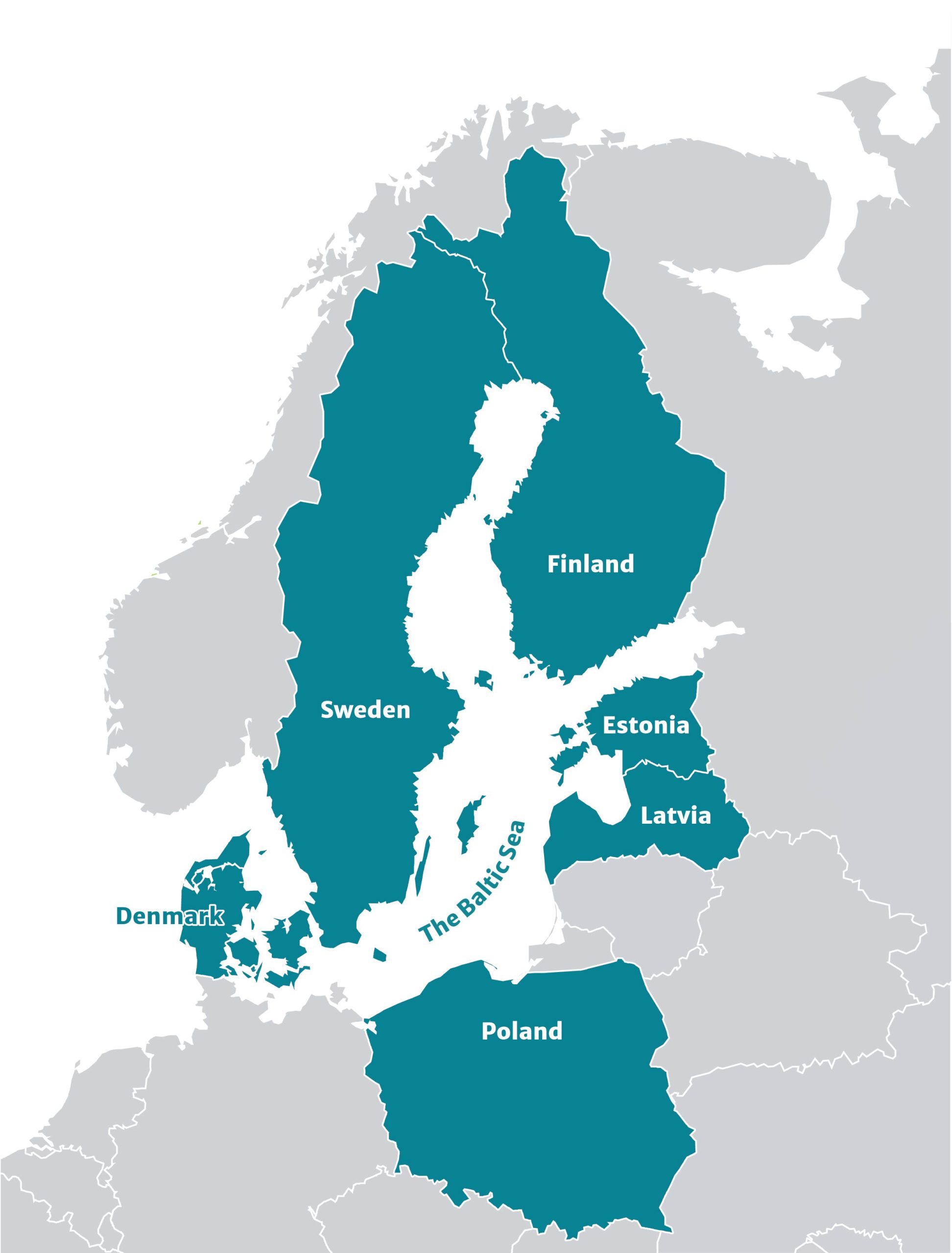
Site description  Ogre is located alongside the Ogre river approximately 50 km from the Baltic Sea coastline. The pilot area of Ogre has been selected due to its significant flood problem and estimated future challenges caused by climate change. The focus is on the Loka street neighborhood (between AHS1 and AHS2 – see the photos), which has developed from a low swampy meadow. The Loka street area’s surface water run-off drains into the Ogre river through open ditches. When the river’s water level rises e.g. due to ice blockages in the spring, the stormwater outlet gets blocked, resulting in flooding.

Due to intensive detached housing construction, part of the ditches have been arbitrarily filled or the culvert elevation marks have been misaligned. This has led to a loss of functionality of the existing drainage network. To control surface run-off, the municipality must provide rainwater drainage from the street and adjacent areas by creating a single network. Therefore, the municipality has started the gradual construction of a rain drainage piping system, which is supported by NOAH installations.

NOAH actions  A Storm Water Management Model (SWMM) is created for the area. Measurements of the Ogre riverbed upwards from Daugava river water reservoir are performed (including measurement data processing and cartographic material preparation). Sensory locations as well as the technical design of the Automatic Hydrological Stations (AHS) are identified and evaluated. A total of three AHS are installed in Ogre, consisting of e.g. water level meters and flow meters. With the help of the AHS, water level and water flow in the river can be monitored in real-time.

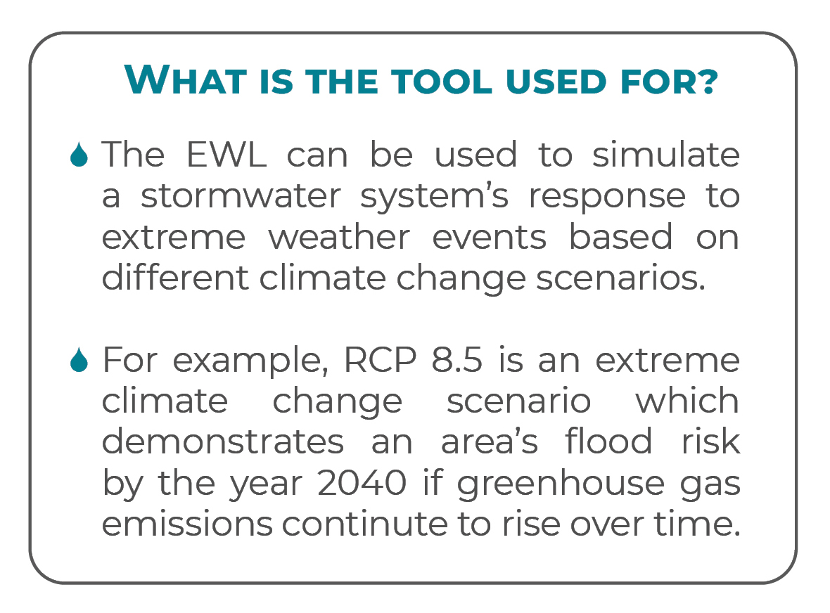
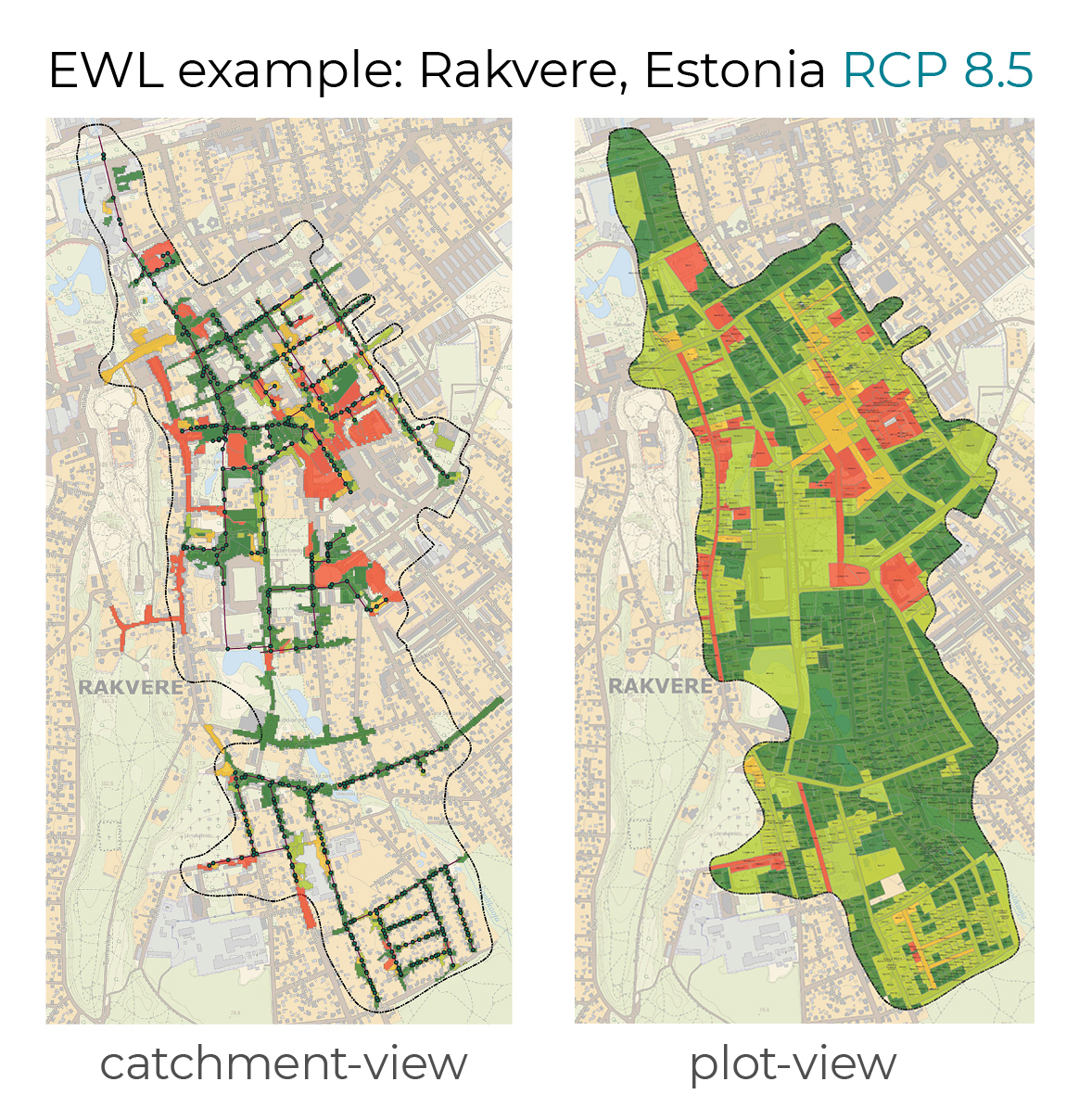
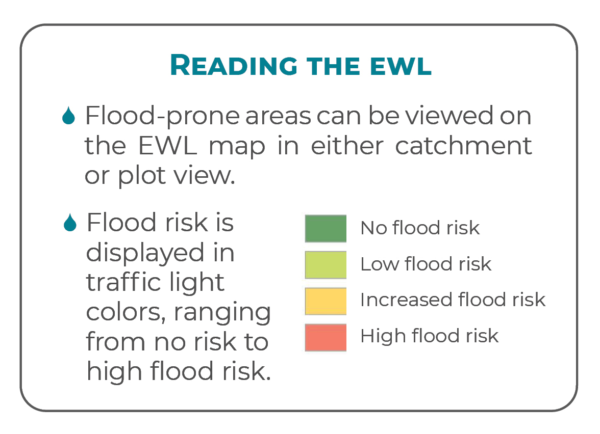
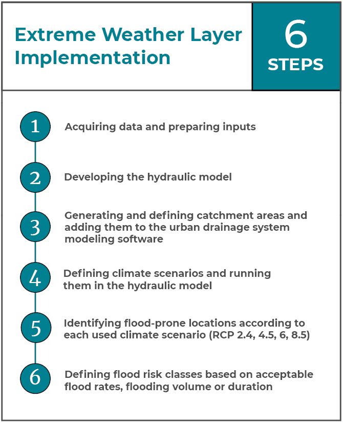
The Extreme Weather Layer (EWL)  is also created for the pilot area as a tool to assists in spatial planning and flood risk prediction. An additional 3D river flood model, specific to the Ogre pilot site, is created. The model was generated from a combined drone-created point-cloud and LIDAR distance data. The model results are used in short-term forecasting (24 h), that also works as an alarm system in case there is a flood-warning on the Ogre river. The alarm system informs the potentially affected citizens via SMS or e-mail. 

Site description  Liepaja is located in western Latvia, between the Baltic Sea and the lake of Liepaja. The NOAH pilot areas are located in two separate locations in the city – Tebras Street catchment basin and Cietokšņa channel areas. Most of the area is occupied by low-rise residential buildings, and impervious surfaces consist of roofs (42%) and paved roads (8% of total area). The stormwater sewer outlet of the Tebras street catchment discharges water into the Lake of Liepaja in the Natura 2000 protection area. There is also a problem related to backflow from the lake with water standing still all the way from the outfall to the pump.

NOAH actions  Hydraulic model of the Tebras street catchment basin is developed to (a) clarify how the sewer functions under different circumstances, (b) examine whether it is possible to add new connections to  this catchment basin in the  future, (c) understand the quality of water drained from the catchment basin. A tidal gate and a pump are installed in the outlet to prevent sea water from backing up into the drainage system.

An Automatic Hydrological Station (AHS) is installed in Liepaja. The AHS consists of e.g. water flow meters (installed in manholes closer to the city center) and water level sensors (installed in the Cietokšņa channel). The northern part of Liepaja nearby Tosmare lake is enclosed by Cietokšņa channel. The level sensors are installed because the territories around the channel are potential flood risk areas and sensors are needed to indicate water level rise in the channel. The main problem in Liepaja is that if the Cietokšņa canal outlet into the Baltic Sea is clogged, the adjacent areas get flooded. The Extreme Weather Layer (EWL) as a planning tool for more flood resilient urban space is also created for the pilot area to help predict flood events based on different climate scenarios. 

Site description  Slupsk is situated in northern Poland, about 20 km from the Baltic Sea coast, on the Slupia river. The selected area (pilot site) does not include the entire sewer system operated by the Słupsk Water Supply but the most densely built-up area of 22km² where both, the separate and combined sewer systems exist. Even though the share of combined sewer system is small, approximately 30% of the total flow originates from the stormwater entering the sewer system via unsealed manholes and pipes. This poses a risk to the wastewater treatment plant (WWTP) and to the Slupia River, which is the recipient of the overflows. The modelled network has one main outflow from which the wastewater and stormwater is pumped to the WWTP. The excess which cannot be pumped is stored in the retention tank upstream from the pump or discharged to the Slupia River.

NOAH actions A Storm Water Management Model (SWMM) is created for the area. To collect data, precipitation meters (rain gauges) with an automatic data archiving system and remote transmission are installed in six locations in the city. In addition, devices for measuring the water level of the main sewage channels are installed in 12 locations. In order to improve the flood issues in the city, there is a need for retaining and delaying water upstream of the affected areas. The Extreme Weather Layer (EWL) as a planning tool for more flood resilient urban space is also created for the pilot area to help with planning climate-resilient urban areas. 

Click the locations on the map to see photos of the sites.

Pilot site actions & results

The NOAH pilot site actions and results are presented in videos as part of the output 4.2 Visualization of the results. Each video gives a general presentation of the current impacts of climate change and extreme weather events on stormwater systems. The videos consist of a presentation of the NOAH framework, an introduction to the NOAH actions, an overview of the NOAH Extreme Weather Layer tool and lastly, a summary of the NOAH project impacts and positive outcomes. In addition to the pilot site videos, A4-sized leaflets were created, giving the essential information in a summarized format. See the written report O4.2 Visualization of the results for further details of the activity.  

Pilot site leaflets

NOAH Tool – Extreme Weather Layer

The Extreme Weather Layer (EWL) is a new tool created in the BSR NOAH project for spatial planning and flood risk mitigation in urban areas. It is built on the model of an existing stormwater system and is a combination of hydraulic modelling, climate scenarios and other urban planning datasets.

The EWL helps experts to prepare for future challenges in the field of water management and to develop the climate-resilience in urban areas. With the assistance of the new planning layer, the most suitable solutions for flood mitigation can be implemented in the areas with the highest flood risk. Further, the effects of the solutions can be analyzed – how the new developments change the flooding risks on plot-level, district-level or city-level in the selected area.

The EWL tool is created for each urban area individually. It is based on the hydraulic model of the urban drainage system (UDS), unique for each city, and the geographic information system (GIS) data of the city, also unique. The EWL is the methodology for combining the model and GIS so that the flood prone areas can be analyzed.

The steps for creating the EWL are described below. Further information on the EWL concept and set-up is available in the NOAH Output 2.4 Report on pilot implementation of Extreme Weather Layer.

The NOAH tool is also part of the Baltic Smart Water Hub, an international platform sharing solutions and tools with experts in the Baltic Sea Region.

Project outputs & reports

Media releases

Articles and media releases 2021

Articles and media releases 2020

Articles and media releases 2019

NOAH on social media

More about NOAH

Floods causing inflows of pollutants into the Baltic Sea

Effective control of the stormwaters in urban areas is one of the biggest environmental challenges in the Baltic Sea region as climate change brings along intense rainfalls and storms. Urban drainage systems are not capable to handle the floods, which rises the risk of flushing untreated wastewater from urban drainage systems into the nature. This is harmful to people and environment due to the excessive amount of nutrients, hazardous substances and pathogenic microbes in wastewater.

Holistic planning and smart drainage systems

Urban areas can be prepared for floods by improved planning and self-adaptive drainage operations. NOAH project brings together nine towns and water utilities, seven academic and research institutions and two umbrella organisations from six countries around the Baltic Sea to join their forces.

NOAH’s approach is to create a concept for holistic planning and implement smart drainage systems in real urban environments. Holistic solutions combine stormwater management with spatial planning. This is followed by development of smart drainage systems to make the existing facilities resilient to the impacts of climate change.

Healthier and cleaner Baltic Sea

The NOAH concept will be easily scalable to any urban area around the Baltic Sea. Implementation of the concept could cut up to half of the inflow of pollutants into the Baltic Sea. The activities will be anchored into daily practices of towns and water utilities, leading to healthier and cleaner Baltic Sea!

Contacts

Ivar Annus
ivar.annus(at)taltech.ee 

Hanna Rissanen
hanna.rissanen(at)samk.fi